Sept. 7 - Today's itinerary was to drive 297 km to Paryang [4,750 m/15,440 ft.] from Saga. It had rained the previous night, so some nearby mountains around had a nice dusting of snow. At 15,000 ft, weather can be truly unpredictable. But it was clearing up in the morning, and warmed up to 70 degrees during the day.
One expert group was here to do an Inner Kora. This is the first time I heard about such a thing as Inner Kora. This one takes you much closer to the main Kailash massif and involves rock climbing. Looking at pictures on the internet, it would be a great experience to get so close to Kailash - up, close and personal. For those interested, watch - the Swastika is clearly visible, and the little hill front right is Nandi the bull.
There are gravel and rocks of a variety of shapes, colors and sizes on the shore (we brought some samples back.) Some shrubs and grasses all around as well. We were expecting the water to be very cold. One Indian had entered the water just ahead of us, to pray and take a bath. He had gone several feet in, but the water was still shallow - less than knee deep. The water was muddy and not at all appealing. And it was warm - like 70 degrees. Kedar had decided NOT to take a bath or drink the water EVEN BEFORE we entered Tibet, and now, even I wasn't sure.
We turned back to the guest house. It was pretty quiet. The weather was calm, although some clouds were floating in. Gurla Mandhata was in clouds the entire time, but to the North, Kailash was still visible. Clouds were higher up, or behind Kailash - either way, we could see Kailash until sunset, and later in the moonlight. We were five days away (Sep 12) from Full Moon. Can't wait to see the moon behind Kailash.
At night, I kept stepping out of the room to view Kailash in the moonlight. Just an awesome feeling. Later, after the moon set, the sky was unbelievably full of bright stars glowing like you never see in big cities.
Our guide and driver were ready and waiting for us. We ate breakfast, rested for some time, and then spent the afternoon with "Excursions at Manasarovar."
First stop - Rakshas Tal (literally meaning 'The Monster Lake') is a smaller lake just west of Mansarovar, and is shaped like an upside down footprint. Legend has it that its water is poisonous and should not be touched or drunk. According to Hindu beliefs, Ravana- the devil of Ramayana, did an extended prayer and a very tough meditation to please Lord Shiva and later received blessings from the god in the Raksas Tal itself. Ravana, himself being a Raksas (a monster/devil), added to the dark myths associated with the lake.
Locals of the region avoid the Raksas Lake believing its unholy water will bring ill-luck. But when a goldfish was sent to Raksas Tal from Mansarovar Lake letting the holy water from Mansarovar flow into the Raksas Lake, people started believing that the Mansarovar's water washed out all the poisons from the sinister lake. Whatever the myths say about the lake, Raksas Tal is visually divine and a visit to the lake can be a fulfilling experience.
We drove about 15 km South for a closer access to the lake. Unlike Mansarovar, there was no soul around Rakshas Tal - not even animals. The shore was quite a distance (1000 ft) from the road with several small bluffs in between. Water levels must have been much higher in the past. The shore as well as water were clean and crystal clear - Our driver and guide chose to stay by the car and warned us about the water being "poisonous." Later, our guide mentioned that it was really salty. If I had known that earlier, I would certainly have tasted it to be sure (That would have really made him distraut!)
Instead of taking the longer path from the right, our guide took us straight up on the left side. We were here to hike after all. This monastery is built around a cave - inside you find a meditation cave, a conch shell shaped stone, as well as a Kailash shaped image on a black stone/slate. The view of Mansarovar from here is amazing. We came down the hill the same way we went up. Of course, coming down is a lot trickier because of all the loose gravel and rocks on the path.
Because of us, our Tibetan guide and driver also took a bath in Mansarovar - this was their first time. They enjoyed it so much that they were in the water for another 15-20 minutes, taking pictures of each other swimming. We also collected a fresh batch of Mansarovar water - just two half liter bottles for us, but the Tibetans filled in a lot more to take back with them. This water was just as clear as our bottled water. After returning, I treated it with chlorine tablets. (The water made it back to the US, and many, many people in the Bay Area - our friends and family - had a sip of it - and have their sins wash away. It is amazing how fresh that water tastes even so many days later.)
There are hot springs behind Chiu Monastery (and many other places around like Tirthpuri and Saga), but we skipped them. Feeling refreshed and relaxed, we returned to our guesthouse. Before sunset, we once again went for an hour's walk along the lake. There were occasional walkers, but otherwise, very peaceful and quiet.
At night, we had dinner at the guest house kitchen. The lady owner had a 3 year old girl running around. She was very interested in talking to us, so we taught her some words like Hi, Hello, Bye, and like any other 3 year old, she picked them up very quickly. One word she already knew was Money! I had a pack of color highlighters - I taught her names of all the colors, and then asked her to pick one. Guess which one she picked? Pink, of course.
Here is the background for the reference to "Moon behind Kailash." Lord Shiva supposedly resides on top of Mt Kailash (or Mt Meru, the center of the universe.) As the story goes, to create life (land?) on earth, Gods and Demons combined their powers to stir up the ocean using Mt Meru.
First thing to come up was "Halahal" poison. To protect earth from the poison, Lord Shiva swallowed it - turning his throat and rest of the body blue. In order to cool him down, he wore a snake around his neck, river Ganges came down from the heavens, and the crescent moon rested on his head. We already know that one of Ganges' tributary Karnali originates in this region. We also know that the moon could only be seen behind or above Kailash from certain angles. We went entire 360 degrees around Kailash. A crescent moon, as seen in the picture below, would be in the West around sunset if you are East of Kailash - as we were today. But given that it was Full Moon today, it would rise in the East around sunset wereas Kailash would be on our West. Only around midnight, Moon could be over Kailash. During our days here, the two just did not coincide, or were clouded up. So we will just imagine this picture for now.
We spent the afternoon resting. There were two new groups in rooms adjacent to us - one trekker couple from Switzerland and another group from Australia of five women with their female guide from Nepal and husband of one of the trekkers. The Swiss couple was remarkably apprehensive about this trek even though they had climbed to 5,000 m in Alps. They were asking a lot of questions and reading about it in Lonely Planet Tibet book. The Australian group had a mix of experience - coming from Kathmandu, Nepal, they were all affected by Altitude Sickness. On top of that, the husband had lung infection after taking a bath in Mansarovar - so he was going to stay at Darchen for three days. We gave him our extra cup-a-noodles that we were tired of eating and had no need for after today. We tried to cheer both groups as best as we could. Hope their treks were successful.
Had some eggs, potato and pita bread for dinner, and rested. This morning at the tea house, my right knee was kind of tender after the three days of hike. So ONLY for the last two hours, I put on a knee cap (Big mistake.) It was snug and supported my knee well. But when I took it off after reaching Darchen, I realized that the knee was swollen to the point that I could not even bend it, nor could I walk without limping. Thank god, I didn't try that earlier. The Swiss couple had analgesic ointment, which gave temporary relief. But I was limping for several days (except when we were at the Everest Base Camp. That day, there was no pain. Go figure!)
I was glad that Kedar made it the entire way, considering that this was really his first high altitude trek. We were tired -- exhausted really, but happy. This IS an experience of a lifetime!
Another day saved (at Paryang) - we may stay an extra day at Everest Base Camp, or return to Lhasa a day early.
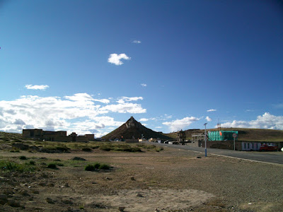
Until last year (2010), today's trip would have taken the entire day on bumpy roads and detours. But because the roads are now nicely paved over, we reached Paryang around lunch time (1:30 PM.) Paryang is a sprawling dusty town with winding alleys - a town to forget.
Our driver was looking for, what I thought, some lunch place that will serve their favorite dish. (e.g. Dumplings with Yak Meat. Other choices were Noodles, Noodles and Noodles! Kedar and I normally ate light breakfast [read: a poptart], skipped lunch and had noodles for dinner. Our appetites were generally low, and our guide used to wonder how we survived on so little! On the other hand, we used to wonder how THEY ate so much, and still stayed skinny! They would have good solid breakfast, and lunch, and dinner, AND they snacked while driving on top of that.)
Instead, he parked in a courtyard and declared "we are staying here tonight." Not seeing any reason to spend the rest of the day in Paryang doing nothing, we suggested that we continue on to Mansarovar - another 200 km. Both the Driver and Guide were only too happy to oblige, but they wanted me to ask. For groups coming from Kathmandu, Nepal (3000 ft), this is a required stop for acclimatization. Having been in Tibet already for 7 days, we were fairly acclimatized by now. One noticeable thing about Paryang was that almost every hut/house had a solar panel by the front door and a battery connected to it. Not surprisingly, Tibet is the most "Solared" place on earth.
We will now get one extra day at our primary destination - the Kailash Region. What more can you ask for? I suppose, clear weather and fantastic photo opportunities!
All seven of India's sacred rivers "supposedly" originate from the Kailash region. Per Hindu mythology, Ganges actually landed on Lord Shiva's head at Kailash. In reality, only Sutlej originates from Lake Mansarovar. Others originate or have tributaries that originate from this region. Brahmaputra - daughter of Brahma - originates from a lake not too far to the East of Mansarovar. Pretty much since we left Lhasa, we were driving parallel to, mostly to North of, Brahmaputra, which flows eastward towards the Bay of Bengal. Tibetans call it the Yarlung river, and Yarlung Valley is where Tibetan civilization got its start.
Brahmaputra is sometimes wide and quiet, and other times narrow and forceful (wild!). It would be awesome fun to water raft down this river. As usual, the first chance we got, we stopped so I could walk up to the river. The water was white with lot of silt/sediments - no chance of drinking that one either. It was not very cold though. Further up, we reached the lake from which Brahmaputra originates (29.835879,83.739166.) The lake was visible but far away. Between the road and the lake, there were amazing sand dunes. There was just one other vehicle with a Chinese couple on their honeymoon and their guide.
In a matter of hours, after one of many ATP (Alien Tourist Permit) check points, we reached the vista point for Mansarovar (4:30 PM). Just over the last hump (pass), we saw the entire expanse of Mansarovar in front of our eyes (due West). Kailash was visible underneath the clouds on our right (North), whereas Gurla Mandhata to the left (South) was completely covered in clouds. Tibetans consider Kailash the father, Gurla Mandhata the mother, and Mansarovar the daughter. (I couldn't find any reference to Gurla Mandhata, or a Hindu name, in any Indian literature.) Such an awesome sight! I was thrilled. Even if we had to turn around and go back after this view for some reason, I'd be satisfied.
The lake shore was some distance from us and not easily accessible by car from this particular location. The guide promised us a much better access to the lake in a couple of hours, so we drove on. Lake Mansarovar (Mapham Yum-tso or Victorious Lake) is one of Tibet's most beautiful lakes. Unlike Yamdrok Tso (Turquoise in color), Mansarovar and neighboring Rakshas Tal are both Azure Blue. Mansarovar is considered as pious and pure, so Hindus (but not Buddhists) want to take a bath in it, drink the holy water, and wash away their sins. Tibetans consider Full Moons special, and drink a spoonful of Mansarovar water (also water from Mount Everest / Quomolangma, as we found out later.) on those special days.
Manasarovar is said to be the world's highest freshwater lake. It lies on the high west Tibetan plateau, between the massif of Mt. Gurla Mandhata (7,694 m/25,300 ft) and the pre-Himalayan range which runs parallel to the Himalayas, with sacred Mt Kailash at its heart some 40 km to the north. Pilgrims come here to perform the parikrama, the sacred clockwise walk around the lake - a nearly 90 km (56 miles) walk that takes four or five days. Few westerners do the whole walk. Instead, they often do day walks in the best areas, especially around Chiu Monastery.
From a distance, Mansarovar is no doubt impressive. Since no large trees grow at this elevation [4,560 m/14,820 ft], you have a clear view of the entire 90 km expanse of the lake, and more. The lake is large enough to have waves, but overall the water is extremely calm. At the deepest point, it is about 300 feet deep, but pretty shallow around the shore. The mythical stories of Raj Hans (Swans - who may migrate here during Summer) and lotus flowers making Mansarovar their home, are just that -- mythical. All we could find were some smaller ducks, as you see in this picture, and only just a few of them. May be we missed the season.
 |
| First view of Mansarovar and Kailash |
Kailash is about 60 km away from this location, but its South and East face are clearly visible. We then drove half way around the lake to Chiu Monastery (Chiu means a bird -- like a sparrow in Marathi songs.) We will stay here two nights, instead of just one as originally planned. Chiu Monastery, perched on top of a rock for a grand view of Mansarovar to the East, and Kailash to the North, is situated between Mansarovar and Rakshas Tal. In fact, the natural channel (Ganga Chu) joining the two lakes is right adjacent to the Monastery. Tibetans consider it good luck when the water flows from Mansarovar to Rakshas Tal. Currently, the water levels are too low - and receding - for the water to flow in either direction. (Blame it on Global Warming and receding glaciers!)
There were a couple of guest houses near the Chiu Monastery, only steps away from Mansarovar. A new 3 story one is being built even closer to the lake (right in the picture below.)
 |
| Chiu Monastery and hotels in front |
Most tour groups stay around here. Indian tour groups, which are typically much larger, and stay longer, bring their own tents and cooking facilities. Pilgrims do prefer to stay in the guest houses, if possible. That's why, the first, larger, guest house (left in the picture above) was full by the time we arrived. Indian pilgrims were praying, singing Bhajans and doing Parikrama around the lake. Only a handful of Indian pilgrims venture to do the 3-day Kailash Parikrama, so the rest of the group spends days at Mansarovar during that time.
Any case, we ended up staying just across the street at another guest house (30.763637,81.370438.) Just as well! We were still only steps away from the lake. And to see Kailash, we only had to open the door of our room. How can you complain?
All guest houses, it turns out, charge the same rate. The deciding factor is which one the guide or the driver prefers - because of better food, cleaner rooms, or because they know the owners. Our room had six beds, but the owner guaranteed that there will be just the two of us in our room. The same cots, mattresses, pillows and blankets (all unwashed.) Kitchen a few steps away, and pit toilets further down. Pit toilets were a new addition in 2011.
It was around 6 PM and there would be light for another couple of hours. We walked to the lake to check out the water, possibly taking a bath and also bringing some lake water back with us. The paved road ends about 50 feet from the water (from where the above picture was taken.)
 |
| Colorful view of Mansarovar |
Looking for better, clearer water, we walked a couple of miles South (counter-clockwise like Bons do.) and kept testing the water. In one place, the water was much clearer because it was filtered through the grass, but a tiny fish made it in to my bottle. Hmmm, may be I should have brought that one back! Further down, we found a spot where we were satisfied with the water quality and clarity (by comparing it with the bottled water we had with us.), brought a couple of half liter bottles back. I treated them with Chlorine tablets, just to be sure.
We turned back to the guest house. It was pretty quiet. The weather was calm, although some clouds were floating in. Gurla Mandhata was in clouds the entire time, but to the North, Kailash was still visible. Clouds were higher up, or behind Kailash - either way, we could see Kailash until sunset, and later in the moonlight. We were five days away (Sep 12) from Full Moon. Can't wait to see the moon behind Kailash.
At night, I kept stepping out of the room to view Kailash in the moonlight. Just an awesome feeling. Later, after the moon set, the sky was unbelievably full of bright stars glowing like you never see in big cities.
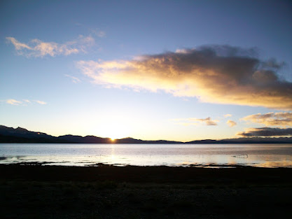
Sept. 8 - Next morning, I woke up early to not miss the sunrise at Mansarovar. Since China observes only one time zone (Beijing time), the sunrise was around 8 am and sunset 8 PM - two hours behind Beijing.
 |
| Sunrise over Mansarovar |
Our guide and driver liked to sleep in late, so we were planning a late start for today's excursions. The sun came up around 8:15 am. And within ONE minute, it came out fully. It was blindingly bright even through the camera, and the sun rays felt hot. Kedar was happy to see the pictures later.
We had debated about how to prepare for this 3-day trek. Although we haven't had much problem with altitude sickness per se, we tired easily. Even after 10-12 hours of sleep, we would wake up feeling tired. Climbing 300 steps of Potala Palace got us winded - and that was ONLY at 12,000 ft. Now, we are 3,000 ft higher, and we had to trek 20 km each day while carrying our own backpacks in only a couple of days. Better start "getting in shape!"
So, we loaded up our backpacks and set out towards the lake going clockwise. The entire lake perimeter is flat, as you can see in the pictures above. So not much challenge trekking that way. We started walking directly in the direction of Kailash to see if there would be a better view beyond the ridge. We must have walked 4-5 km closer to Kailash, but the view got worse instead of better. No sooner than we reached the top of the first ridge, we found the next one higher than the first, and so on. We finally turned around and came back to the guest house at 11:30 am. At least, we could experience how climbing at that altitude and carrying our backpack felt like - and now we knew that we could make the trek. We also planned to hike next day to the nearby Fire Hill (30.759647,81.365025)
 |
| Kailash Region landmarks |
First stop - Rakshas Tal (literally meaning 'The Monster Lake') is a smaller lake just west of Mansarovar, and is shaped like an upside down footprint. Legend has it that its water is poisonous and should not be touched or drunk. According to Hindu beliefs, Ravana- the devil of Ramayana, did an extended prayer and a very tough meditation to please Lord Shiva and later received blessings from the god in the Raksas Tal itself. Ravana, himself being a Raksas (a monster/devil), added to the dark myths associated with the lake.
Locals of the region avoid the Raksas Lake believing its unholy water will bring ill-luck. But when a goldfish was sent to Raksas Tal from Mansarovar Lake letting the holy water from Mansarovar flow into the Raksas Lake, people started believing that the Mansarovar's water washed out all the poisons from the sinister lake. Whatever the myths say about the lake, Raksas Tal is visually divine and a visit to the lake can be a fulfilling experience.
We drove about 15 km South for a closer access to the lake. Unlike Mansarovar, there was no soul around Rakshas Tal - not even animals. The shore was quite a distance (1000 ft) from the road with several small bluffs in between. Water levels must have been much higher in the past. The shore as well as water were clean and crystal clear - Our driver and guide chose to stay by the car and warned us about the water being "poisonous." Later, our guide mentioned that it was really salty. If I had known that earlier, I would certainly have tasted it to be sure (That would have really made him distraut!)
 |
| Rakshas Tal - clear water |
 |
| Rakshas Tal - far away from the road |
 |
| Rakshas Tal - looks just as pure to me! |
We then drove back up North a little and took a detour on a dirt road towards Mansarovar and South again to the Gossul Gompa (monastery.) There were eight monasteries around the lake, representing points of the Dharma wheel, until the destruction of the Cultural Revolution. Five of those have been rebuilt, in part at least. This Kailash Mansarovar region has always been a poor, utterly remote area - inhabited by nomads and brigands - many months away from the civilized world. As a result, the lake's monasteries are basic affairs compared with the riches and beauty of those in Tibetan heartlands.
 |
| Gossul Gompa - straight up! |
On our way back to the hotel, a short distance from the Monastery, our driver knew a perfect spot for bathing. The water was cooler and deeper here than yesterday. It was so refreshing to take a bath -- and of course, to see our sins wash away!!! We were in the water for quite some time. Looking North towards Kailash, we prayed to the "real" Vyadeshwar, our family deity and another name for Lord Shiva.
 |
| This bath is so refreshing! |
 |
| This is for you, Baba! |
There are hot springs behind Chiu Monastery (and many other places around like Tirthpuri and Saga), but we skipped them. Feeling refreshed and relaxed, we returned to our guesthouse. Before sunset, we once again went for an hour's walk along the lake. There were occasional walkers, but otherwise, very peaceful and quiet.
At night, we had dinner at the guest house kitchen. The lady owner had a 3 year old girl running around. She was very interested in talking to us, so we taught her some words like Hi, Hello, Bye, and like any other 3 year old, she picked them up very quickly. One word she already knew was Money! I had a pack of color highlighters - I taught her names of all the colors, and then asked her to pick one. Guess which one she picked? Pink, of course.
Sept. 9 - At night, winds picked up, and brought clouds and rain along. Winds were howling so hard that it felt like pouring rain - it wasn't that bad. When we woke up, it was completely cloudy with some drizzle. It took some determination to get out, but we still hiked up the nearby Fire Hill (30.759649, 81.364982) It took us about an hour to climb up to the top - which was as usual adorned with prayer flags. Nearby there was a transmission tower, powered by solar power. The hill is full of rock and flint stones - hence, the name. According to the legend, Lord Shiva cooked a meal here. Rain/drizzle had stopped by the time we reached the top. Rest of the day, it was clearing up, but there were still clouds on the horizon.
 |
| Hotels near Chiu Monastery |
 |
| Rocky top of Fire Hill |
We returned to the hotel, checked out, and drove to the base of the Chiu Monastery which was merely a few hundred yards from our hotel. We needed to continue on to Darchen and our guide was anxious to get there before other Indian groups did. Monastery has a cave inside where Guru Padma Sambhava meditated for months. As usual, steep steps to the top and awesome views.
We hurried to get the best guesthouse in Darchen (30.97266,81.286828) about 35 km away, but did not. We once again got a room with six beds, but only two of us in it. Darchen is the starting - and end - point of Kailash Kora. It is lined with hotels and small shops, and a lot of new hotel construction. The day was pretty decent, and we had time so (if we had thought about it,) we could have gone to one of the inner monasteries, but we didn't. Considering the cloudiness the next two days, that would have been the best use of that afternoon.
We hurried to get the best guesthouse in Darchen (30.97266,81.286828) about 35 km away, but did not. We once again got a room with six beds, but only two of us in it. Darchen is the starting - and end - point of Kailash Kora. It is lined with hotels and small shops, and a lot of new hotel construction. The day was pretty decent, and we had time so (if we had thought about it,) we could have gone to one of the inner monasteries, but we didn't. Considering the cloudiness the next two days, that would have been the best use of that afternoon.
 |
| Darchen with Kailash in the background |
By now, we were really longing for some different food. Nothing fancy - just bread and jam would have sufficed. But the closest thing to bread we found was Pita Bread, and for jam, honey. Oh well. Later in the evening, a large Indian group arrived. They stayed in the rooms around us, and were crammed six to a room. They had their own cooking staff from Nepal, and were getting fed 3 meals a day, even though their appetites were low too. We had a chance to chat with a family from the U.S. who took this trip with an Indian tour group. Listening to their experiences of traveling with a large group, coming from Kathmandu (vs. Lhasa), etc., we were glad that we didn't sign up for that. Those groups are designed for and well suited for Indians coming from India, possibly the first time out of the country, prefer to have everything taken care of, and save some money along the way. Although we didn't really need a private group just for the two of us, a smaller group of 8-12 (2 or 3 cars, 4 per vehicle) would have been perfect. Also, with appetites being low, having meals included is an unnecessary luxury - as I had realized during the 2009 trek in Nepal.
 |
| Kailash Map |
Sept. 10 (Day 10) - First day of the 3-day Parikrama/Kora. Any reasonably fit and acclimatized person should be able to complete this trek. Having said that, it takes a lot of determination, will power and of course, time to succeed. Today's trek to Dira-puk Monastery [4,909m/16,105ft] of about 20 KM away was fairly gentle climb, almost entirely by the river banks. It was the first test of our endurance to walk so much distance while carrying our backpacks. To keep our load light, we carried only the sleeping bag liner, not the sleeping bag itself. We had food and water only for two days, and decided to take a chance with the last day. There were, after all, food tents along the way where we could find something - noodles for sure. Still, by the time you add winter jacket, gloves, thermals, hiking poles, camera, etc., weight adds up.
Sonam, our guide, wanted to leave at 8 AM sharp (I'm sure to get ahead of the Indian group at the Monastery Guesthouse. So we woke up at 7 AM. It was still quite dark. On my last trek (2009), I had carried a small but powerful flashlight. It worked great otherwise, except when you want both hands free for your morning routine. This time, I had taken a LED headlamp. LEDs are much brighter, and having a headlamp keeps your hands free. As was the case in Nepal, there was a pipe right in the middle of the courtyard of this hotel bringing water from some river/stream higher up. The water keeps running the entire time - no tap. Great for brushing teeth, washing hands, face, hair, clothes, whatever. But such a waste of water!
In the end, we ended up leaving about an hour later. A block up North (towards Kailash in the picture above) and then turn left to begin the trek going westward. Scores of people - Tibetan pilgrims and Foreigner trekkers - were all walking in the same direction. To the left, huge, treeless Barkha plain was dotted with nomadic tents and herds of sheep and goats. From time to time, horsemen/ women/ kids raced their horses past us. We later found out why they were in such a hurry.
An hour later, we reached the first prostration point. Pilgrims were looking in the direction of the sign and prostrating. This is the first of the four points during the Parikrama that you see Kailash - the South and West face. But it was completely fogged in today.
Another hour of walk, the trail passes the famous Tarboche Flagpole and enters the extraordinary glacial Lha Chu valley, a flat, gravelly bottom receding between vast, sculpted red towers, broken crags and huge scree slopes. And a river runs through it the entire way.
Our guide Sonam was waiting here for us. (The driver stayed back at Darchen to take care of the car.) Paved road, which ran parallel to the trek on our left, comes up to this point. Indian pilgrims start their Parikrama here, after getting dropped off by their Toyota Land Cruisers. Most pilgrims promptly rent a horse for three days (at $100 per day.) and ride most of the way. Of course, if you are not used to riding horses, that is no fun either! Any case, the horsemen were rushing past us to get here before the Land Cruisers arrived - first come, first served. In reality, you REALLY need a horse only on the second day up to Dolma La, if at all. Throughout these 3 days, to my surprise, we saw horsemen going in either direction at all times, and asked us if we wanted a ride. So one could walk as much as possible, and then rent a horse only when needed. More on that later.
The river was shallow at this time of the year, and fairly spread out. We could pretty much cross it anywhere if we wanted to. Just across the river, high up was Choku Gompa. On a clear day, you could see Kailash West face from the river, as well as from the Gompa. Not today though. So we didn't visit the Gompa. The rest of the day we walked on the East bank of this river all the way to Dirapuk Gompa.
The longer we walked, the slower we got. Even the slightest climb became dreadful to cross. Finally, we reached lunch spot around 2 PM. Sonam was waiting for us - concerned that we were too tired, and at the same time, anxious to run ahead to the Monastery. He made us drink black tea, and eat some lunch. He then ran ahead.
After resting a bit, we trudged along. No change of scenery until we reach the second Prostration point. Only the base of Kailash was visible here at first. Within minutes, though, it cleared up entirely as we kept walking. The backpacks were beginning to get annoyingly heavy. Kailash had now disappeared behind the valley wall. And the Monastery was not yet in sight. We knew that the Monastery was visible from quite a distance on the other side of the river, and it had a grand view of the Kailash north face. We weren't quite there yet.
Finally, we saw the prayer flags on the other side of the river. Soon, the guesthouse on our side became visible (31.104139,81.320983). We had reached the end of the first day. It was only 4:15 PM, but it seemed like we were walking for ever. Sonam saw us from a distance and came running to take us to our room. You can only imagine how difficult it was to climb the steep, narrow ladder to the second floor of the guesthouse to get to our room. That evening, we didn't bother to climb down at all, not wanting to climb back up. We were that tired. Luckily, the long balcony connecting all rooms (as you can see in the picture) had everything we needed for the evening. Bathrooms at one end, view of Kailash at the other end (South), and later at night, near full moon rising in front (East). They had delivered a large thermos full of hot water. That supplied us plenty of water for freshening up at night and again in the morning, as well as for our cup of noodle. We rested a while, had dinner and still had plenty of time to take in the beauty of the place. It seemed that time slows down around here!
The view of the majestic, famous north face, soaring some 1,700 m of banded rock and ice is mesmerizing - although the best we could see this afternoon was only about half of it. Yaks, having delivered their daily load of food and cooking equipment, were grazing near the guesthouse. Beyond that you could see tents strewn around and a new guesthouse being built. Further beyond, between two hills, you see Kailash. For a closer look, you could take a 1-2 hour trail passing between the hills. I had seen it in the pictures earlier, read about it, and had planned to go at least some distance. In the end, fog that evening as well as next morning, not to mention exhaustion made us drop the idea. Incidentally, the three hills on the north side of Kailash are named Manjushri, Avalokiteshvara, Vajrapani - the idols of these three gods are seen in every monastery.
Sonam, our guide, wanted to leave at 8 AM sharp (I'm sure to get ahead of the Indian group at the Monastery Guesthouse. So we woke up at 7 AM. It was still quite dark. On my last trek (2009), I had carried a small but powerful flashlight. It worked great otherwise, except when you want both hands free for your morning routine. This time, I had taken a LED headlamp. LEDs are much brighter, and having a headlamp keeps your hands free. As was the case in Nepal, there was a pipe right in the middle of the courtyard of this hotel bringing water from some river/stream higher up. The water keeps running the entire time - no tap. Great for brushing teeth, washing hands, face, hair, clothes, whatever. But such a waste of water!
In the end, we ended up leaving about an hour later. A block up North (towards Kailash in the picture above) and then turn left to begin the trek going westward. Scores of people - Tibetan pilgrims and Foreigner trekkers - were all walking in the same direction. To the left, huge, treeless Barkha plain was dotted with nomadic tents and herds of sheep and goats. From time to time, horsemen/ women/ kids raced their horses past us. We later found out why they were in such a hurry.
 |
| Barkha plain to the South - road runs parallel. |
Another hour of walk, the trail passes the famous Tarboche Flagpole and enters the extraordinary glacial Lha Chu valley, a flat, gravelly bottom receding between vast, sculpted red towers, broken crags and huge scree slopes. And a river runs through it the entire way.
 |
| River runs through it. |
The river was shallow at this time of the year, and fairly spread out. We could pretty much cross it anywhere if we wanted to. Just across the river, high up was Choku Gompa. On a clear day, you could see Kailash West face from the river, as well as from the Gompa. Not today though. So we didn't visit the Gompa. The rest of the day we walked on the East bank of this river all the way to Dirapuk Gompa.
The longer we walked, the slower we got. Even the slightest climb became dreadful to cross. Finally, we reached lunch spot around 2 PM. Sonam was waiting for us - concerned that we were too tired, and at the same time, anxious to run ahead to the Monastery. He made us drink black tea, and eat some lunch. He then ran ahead.
After resting a bit, we trudged along. No change of scenery until we reach the second Prostration point. Only the base of Kailash was visible here at first. Within minutes, though, it cleared up entirely as we kept walking. The backpacks were beginning to get annoyingly heavy. Kailash had now disappeared behind the valley wall. And the Monastery was not yet in sight. We knew that the Monastery was visible from quite a distance on the other side of the river, and it had a grand view of the Kailash north face. We weren't quite there yet.
 |
| Second Prostration Point |
Finally, we saw the prayer flags on the other side of the river. Soon, the guesthouse on our side became visible (31.104139,81.320983). We had reached the end of the first day. It was only 4:15 PM, but it seemed like we were walking for ever. Sonam saw us from a distance and came running to take us to our room. You can only imagine how difficult it was to climb the steep, narrow ladder to the second floor of the guesthouse to get to our room. That evening, we didn't bother to climb down at all, not wanting to climb back up. We were that tired. Luckily, the long balcony connecting all rooms (as you can see in the picture) had everything we needed for the evening. Bathrooms at one end, view of Kailash at the other end (South), and later at night, near full moon rising in front (East). They had delivered a large thermos full of hot water. That supplied us plenty of water for freshening up at night and again in the morning, as well as for our cup of noodle. We rested a while, had dinner and still had plenty of time to take in the beauty of the place. It seemed that time slows down around here!
 |
| Rock and Ice Kailash North Face |
 |
| Rainbow over Dira-Puk Guesthouse |
Normal routine around the trek is as follows:
Large Indian groups carry their own food and cooking utensils (on Yaks, of course.), and chefs to cook their special vegetarian meals. Most Indian pilgrims ride horses (but have to get off from time to time in treacherous areas.), though there are a few die hard trekkers who do walk.
Interestingly enough, Indians actually do only 60% of the Parikrama. On the first day, from the starting point of Darchen, they are driven to Tarboche (2 hours walk away) where they pick up horses. On the last day, a couple of hours from Zutul-puk Monastery, horses drop them off at a tea house, where their Land Cruisers come to pick them up to take back to Darchen, another two hours walk away.
Tibetans and Bons, on the other hand, make the entire Kora in one single day - about 14 hours - typically on a Full Moon day. Some do stop ovenight, but they just camp wherever they find open space near the river/stream. Others do Prostration (Sashtang Namaskar) Kora around the entire route, which could take up to three weeks. We saw some of those as well.
Then there are trekkers - we saw mostly Europeans - who start and end theirs at their hotel/ guesthouses in Darchen for full 100% credit, and they are not even religious!
With only a limited number of rooms available and multiple Indian groups coming in, the guesthouse was full today. Thank goodness, Sonam and his friend Tulup (with another group) rushed ahead and secured two rooms - one for us and one for them. Our room had electrical wiring, with a light bulb hanging from loose wires on the ceiling. When we asked, Tulup promptly jumped up, and connected the light bulb properly, only to remember that there is no electricity NORMALLY. Later in the evening, we noticed that other rooms around had the lights on, so we turned on ours. There was power afterall. One large Indian group had paid the guesthouse to run the generator. Oh, how much do we get addicted to these little luxuries of life.
During the entire trek, here at Dira-puk, we are the closest to Kailash and get really up close views. Only wished there was no fog. Still, we could view part of the North face of Kailash to the right, and the near Full Moon rising in the front. Later, it got cloudy and snowed at night. There would be no chance of seeing moon over Kailash.
Sept. 11 - Day two - the hardest but the holiest day of your pilgrimage. By my estimation, we were to climb about 2,500 ft up to Dolma-La (pass) [5,636 m/18,490ft] in about 8 km, and then down nearly 3,000 ft on the other side, with another 14 km of mostly level trek to Zutul-puk [4,790 m/15,570 ft] Monastery.
On a typical day: Yaks get loaded and leave first so the chefs could reach the next stop to cook and keep meals ready for the pilgrims by the time they arrive - we did see Yaks pass us by much later - just when we were about to reach Dolma La. Horses carrying pilgrims, and their Horsemen/ women/ children follow next. Then the fast trekkers. Tibetans were coming by at all times - from babies, to children, to teenagers, to parents and grandparents. They usually paced themselves, stayed together, took stops when needed -- and stared at us when passing by. We wondered what they were thinking. Any case, we were in no hurry as long as we make it to the next stop. There is really no time during the trek when you'd find yourself alone. If nothing else, there are Bons going in the opposite direction.
Today, we left at 8 am. It was still foggy, and Kailash was not visible. It had snowed a bit at night, so the trails were slushy at places. Sprinkling of snow was on the rocks and grasses all around. It was going to be a long day. Sonam rushed ahead as usual, promising to wait for us where we could see sunrise over Kailash - luck permitting. The trail climbed up gradually. We noticed that it was getting brighter by the minute. Around 9 am, the sky miraculously cleared and we saw the first rays of sun shining on the glowing Kailash (below.)
Today, we left at 8 am. It was still foggy, and Kailash was not visible. It had snowed a bit at night, so the trails were slushy at places. Sprinkling of snow was on the rocks and grasses all around. It was going to be a long day. Sonam rushed ahead as usual, promising to wait for us where we could see sunrise over Kailash - luck permitting. The trail climbed up gradually. We noticed that it was getting brighter by the minute. Around 9 am, the sky miraculously cleared and we saw the first rays of sun shining on the glowing Kailash (below.)
 |
| First rays of sun shining over Kailash |
 |
| The Sunrise |
 |
| Within minutes, bright sun and clear sky around Kailash |
We were in luck after all. After taking in the beauty of this place - and a few pictures, we moved on. Kailash would soon disappear behind the hills (on the left in this picture) and wouldn't really be visible again until we get back to Darchen tomorrow.
The trail then began to climb with lots of switchbacks. Horseback riders were passing by us at this time, so we let them take the switchbacks, and we just cut across - through rocks and boulders - making our own path to the top. From what I had read in Lonely Planet and elsewhere, about half way (4 km) up, you reach a plateau and that's where Shiv-Sthal ("Lord Shiva's place") is. We saw some prayer flags there, as well as clothes, but not by the thousands as I had expected. Then again, people had been laying clothes pretty much all along the way.
May be this was the Yama-Sthal, which should be crossed before reaching Shiva-Sthal. According to one belief, Yama-Sthal is the place for symbolical death - Pilgrims leave their favorite item of clothing, a flock of hair or a drop of blood in the hopes that Yamraja, the master of death, will allow them to be born in spirit to pass Dolma La further up.
According to Sonam, Shiv-Sthal is a large rock where people stick their pictures with Yak Butter and is, of course, covered with prayer flags all around. There was no such thing around here, nor was Sonam. We continued on.
 |
| Plateau with stream running on either side. Dolma La ahead. |
Thankfully, the trail leveled off here for some time. This plateau with streams running on either side was a welcome break from the climb. Somewhere around here are "sin tester" rocks. You test how much of a sinner you are, and that should confirm whether this one kora/yatra will wipe out your sins, or not. We didn't find those either - though at one place, we noticed a group of young Tibetans walking around some rocks. We didn't need to test our sins anyways - we already knew!
By the time we reached the bottom of the pass (around 11 am), most horses had already gone by. In fact, some were already returning from the top. One Indian pilgrim fell way behind the rest of his group. He was having trouble walking even on the plateau, and he just couldn't see himself going to the top on his own. Thank goodness for those returning horses, he was able to ride to the top.
 |
| Suddenly, the clouds rolled in. Dolma La is just to the left. |
 |
| Dolma La - straight up! Trail is seen going from left bottom. Trekkers are visible if you enlarge enough. |
At the base of Dolma La Pass, as seen in the picture above, this is what was waiting for us - a steep climb with switchbacks to the top. We also knew that the first set of prayer flags we could see from below, was NOT the top of the pass. There would be 3-4 such false "tops" before the real one.
Any case, it was cloudy now. Our backpacks felt heavy (though they mostly had water and snacks/food, and we had already consumed half of it by now.) Kedar put it best: "I have zero energy. I have been running on sheer willpower up to this point, and am running out of that too." My thoughts weren't much different. This was the challenge we had heard so much about - but facing it in front of you is something else. Sonam had gone ahead to Shiva-Sthal, and he was nowhere to be found so far. We could have missed Shiva-Sthal, but Sonam wouldn't miss us. We decided to just keep going and let Sonam find us.
In such daunting situations, my usual strategy is NOT to look too far ahead. For sure, NEVER to look up to see how far you have to go. Just take one step at a time, and keep on going. Stop if you must to catch your breath or take a sip of water, but not for too long. Unless you keep moving, you will for sure NOT get there. That had worked for me in 2009 during my trek to Everest Base Camp in Nepal, and it worked again this time. We passed the first set of prayer flags, then the next, and then at the third one, Sonam came running towards us. "Here is Shiv-Sthal! Only 4 more km to Dolma La." He was, of course, joking about the latter. The top of Dolma La Pass, as we could see, was just a couple of hundred meters ahead of us - and only 20 m or so higher.
Whether or not this was "real" Shiv-Sthal, it certainly was a large rock with lots of prayer flags, lots of Yak Butter, and lots of photos stuck on them. So it must be something special. Sonam asked if we had brought photos. We were initially planning to leave some articles of clothing, but after reading about how this place looks like a garbage dump, we decided against it. We were only going to leave a nice color copy of the Kanitkar Logo, (the one developed for the Chitpavan Sammelan in Pune in December 2011.) with both Kedar and my signatures and dates. Sonam stuck it on the largest Drolma La rock. We dedicated it to all Kanitkars. We also left a small flock of our hair with it. Death/re-birth formalities completed. We were now as good as new. All of our past sins - and future ones - will soon be forgiven. So we were told!
According to Hindu beliefs, Shiwa-tsal charnel ground is where pilgrims undergo a symbolic death, Shiv Sthal [Literal: Place of Lord Shiva]; a point of no return - here you leave an item of clothing (or hair, teeth or blood) to represent renounced life. People with few sins supposedly find their path to the heavens during this pilgrimage. (As you can imagine, this journey used to be considerably more difficult in the years past, and many pilgrims actually perished during those trips. So much so that when someone passes away, the honorific used for them changes from a "Mr." or "Mrs." to "Kailas-vasi" [Literal: Resident of Kailash.] in Marathi.)
No surprise! For someone with my level of "sin-load," it was entirely unlikely that Chitragupta (the Hindu equivalent of Saint Peter at the Pearly Gates) would allow me such an easy escape. I had to trudge along, continue my climb up to Dolma La Pass (18,466 ft.) to be re-born, and then back down to earth to pay my remaining dues!
A little earlier, we had seen the last of Kailash disappear behind the hills around this pass. It was now misty and cloudy, and about to snow. We noticed the next set of prayer flags appear. This was it. We were there! Dolma La pass. The highest elevation I had ever been to (walking.) We made it! It was 12:30 PM.
Once there, we realized just how many prayer flags were there - by the thousands. In fact, the original pass and the arch on it is now fully covered with flags (see below.) The new path is a few feet above the old one, and that is also covered all around in flags.
Once there, we realized just how many prayer flags were there - by the thousands. In fact, the original pass and the arch on it is now fully covered with flags (see below.) The new path is a few feet above the old one, and that is also covered all around in flags.
 |
| Two poles indicates where the original pass was - festooned with prayer flags. |
 |
| We made it! Dolma La - a few feet higher actually. |
We tossed off our backpacks and hiking poles. Time to celebrate. This was Sonam's sixth Kora. His mother had asked him to offer prayer flags, which he had purchased back in Saga and has been carrying along. He unrolled them; we took photos with them; he asked me to sign our family name and date it; and then we laid them on the top. There were thousands of other prayer flags allowing the wind to take their blessings out across the world. “May all beings be happy”, “ May all find peace,” "Blessings for everyone from the 7th Chakra of the world."
Sonam had to wait for us at Shiv-Sthal for quite some time, so he was keen to go on. He was worried that the large Indian group ahead of us would take all available beds at the Monastery guesthouse. He wanted to rush ahead of them.
We on the other hand were in no hurry. We enjoyed the peace and quiet for some more time. Just then, a stray dog came trotting as if this altitude meant nothing. (Stray dogs are seen on the entire trek. Where there is food...) Even the Tibetans had to rest from time to time, but dogs were fully acclimatized.
No sooner than you cross the pass, the trail drops steeply past the turquoise sacred lake (Gauri Kund) to a long, beautiful valley. Gauri Kund is where Shiva's wife Parvati bathed. Somewhere around here, there is Parvati-Sthal, which we must have passed. From the trail, the lake is only a few meters of descend, but very few people make it there (because they then have to climb back up!) It had also started snowing heavily by now as you can see.
 |
| Gauri Kund - it was snowing pretty heavily by now. |
 |
| Steep drop on the other side of Dolma La brings you to this frozen river. Trekkers on the left. |
We climbed down the steep drop past Gauri Kund. Melting snow had made the path muddy and slippery - this was the only time we really needed hiking poles. Just before crossing the ice patch, we took a lunch break. Bad news - once you sit down, you don't feel like getting going again. Especially so now, knowing that you have to walk another 14 km - with nothing to look forward to. Just past the frozen river, the trail kind of disperses. There are so many different ways to go down the next drop until you get down to the river bank. Some people were hundreds of feet to our right, some others to the left. We took the middle path - the Tibetan trail - which ended up being no path at all. It was just like the Fire Hill - rocks and boulders all around. Tibetans, of course, have no problems with any kind of terrain. At the bottom of that, just by the river bank was a tea house. Sonam was waiting for us there, and in a few minutes, he took off again.
 |
| Rugged terrain - steep slope down to the valley on left. |
 |
| Now the trail levels off, and goes on and on... |
 |
| Closer view of the trail. Vehicles do come here. That's me - the solo trekker! |
 |
| Lonely trail. Clouds were rolling in. |
 |
| Stair step waterfall. |
The rest of the way was pretty flat, but never-ending. It must have been around 6 PM when we finally got to Zutul Puk (Cave of Miracles) Monastery. We were almost the last ones to reach. Sonam dutifully ran down to the trail to meet us and took backpack away from me. Uh-oh! That means we are climbing again!!! The Monastery has be high up, and so were the guesthouse rooms. Finally, we made it to the room for six people. Sonam asked us to select two beds. Two others were already taken. At night, our room was full - all six beds were taken - all six Indians. Two from India, Two from Singapore, and us.
Two Singaporeans were high school buddies, who loved doing these adventures together. Their wives were not interested. When they planned the trip from Singapore, they were told that they needed TWO horses (they couldn't share one between them!), TWO yaks to carry their luggage, cooking stuff and food (because one yak doesn't go alone!) and ONE cook and of course, a guide. Even though they were fit enough to trek, they rode their horses part of the way only because they were paid for. Thank goodness, our sales director didn't push us to have an entourage, instead encouraged us to do the trek on our own.
The other two Indians reached after us. They were part of the larger Indian group and got their meals served in the room. The rest of the group was in tents by the river below, and were complaining about it being muddy. The entire guesthouse was full. In fact, some trekkers had to continue on to Darchen due to lack of accommodations at Zutul Puk.
 |
| Near Full Moon rises at Zutul Puk (9:30 PM.) |
We had good discussions about various topics including the favorite one - U.S. vs other countries. Being very tired, we fell asleep quickly.
Sept. 12 (Full Moon)
Sonam came to wake us up around 7 am, so we could leave around 8 am. The Indian group got served bed tea, and they graciously offered us. Indian tea after a long time was a refreshing change. We all got ready and left for Darchen around 8 am. Today's trek would be about 12 km - generally flat and downward. In two hours, we would reach the tea house, where the caravan of Land Cruisers would be waiting to take most pilgrims back to Darchen. Only a few trekkers like us, and Tibetans would continue to walk back to Darchen, another two hours away.
Before leaving the monastery, we had to see Milarepa's cave. The monastery was small, but with a lot of history. It was rebuilt after the cultural revolution. The cave is a small and low one, and the tale is told that Milarepa pushed the ceiling higher with his hands - his palms are still visible in the rock. Then it became too high, so he pushed it down - showing footprints and elbow prints. Milarepa stories are deeply connected with the Kailash region, including him climbing to the top. Some scenes from today's trek, with beautiful sights of the mountains and a great canyon.
 |
| Day 3 - the end is near. |
 |
| River gave us company the entire way. |
 |
| Finally saw Gurla Mandhata. Rakshas Tal on right. |
 |
| Looking back from the tea house (10 am.) |
The day was bright and clear. Only wished yesterday was too! We had left ahead of most others today, and reached the tea house at 10 am. The caravan was waiting for their pilgrims to return. As they reached the tea house, there would be great commotion - with pilgrims tipping their horsemen or yalkmen or porters, getting back in their vehicles and rushing back to Darchen. Sonam was waiting for us here, and networking to find future business. After watching the "end of trek" scene here and resting a bit, we started back to Darchen [4560m/14820ft] - now the crowd had thinned out. Only Tibetans and a handful of trekkers like us. Horsemen were anxious to collect their tips here and then rush to Tarboche to take the next group of riders around the trek. Once again, first come, first served - so they were racing. Those poor horses! Hope that they at least get fed well - after all their owners charge tourists $100 per day.
To the left (South) of us, not too far away was the road to Darchen. Farther away, we continued to see Rakshas Tal and Gurla Mandhata the entire way, but Kailash was still hidden behind the nearby hills - until we returned Darchen around Noon.
Today, September 12, Full Moon. Tibetans do the entire Kora in one day on Full Moon - we finished ours on Full Moon. So we get a partial credit, I suppose. Clouds were rolling in, some rain and then clearing. In the evening, moon rise was visible although there were clouds around. Kailash was visible to the North, but moon will not be behind it today at all.
 |
| Full Moon rising beyond the hills. |
 |
| Last view of Kailash - without clouds |
Here is the background for the reference to "Moon behind Kailash." Lord Shiva supposedly resides on top of Mt Kailash (or Mt Meru, the center of the universe.) As the story goes, to create life (land?) on earth, Gods and Demons combined their powers to stir up the ocean using Mt Meru.
 |
| Samudra Manthan i Mt Meru used to stir the ocean |
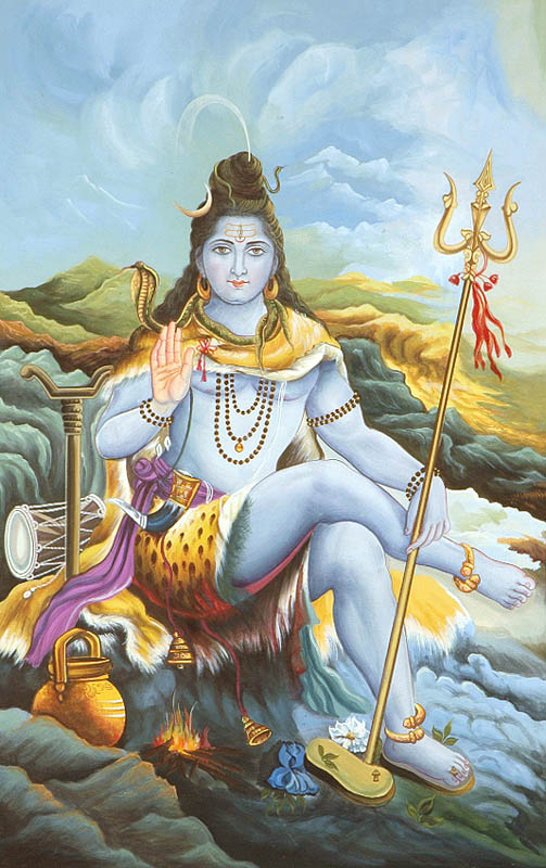 |
| Lord Shiva at Kailash - Crescent Moon and Ganges on top. |
Had some eggs, potato and pita bread for dinner, and rested. This morning at the tea house, my right knee was kind of tender after the three days of hike. So ONLY for the last two hours, I put on a knee cap (Big mistake.) It was snug and supported my knee well. But when I took it off after reaching Darchen, I realized that the knee was swollen to the point that I could not even bend it, nor could I walk without limping. Thank god, I didn't try that earlier. The Swiss couple had analgesic ointment, which gave temporary relief. But I was limping for several days (except when we were at the Everest Base Camp. That day, there was no pain. Go figure!)
I was glad that Kedar made it the entire way, considering that this was really his first high altitude trek. We were tired -- exhausted really, but happy. This IS an experience of a lifetime!
Sept. 13 The sky was clear pretty much the entire night and Full Moon visible. Around sunrise, the sky was cloudless for this picture. Later in the morning, clouds rolled in, and that's the way it was rest of the day.
 |
| Full Moon setting in the West - Darchen. |
We left Darchen around 10 am and drove to the Vista Point - to the rocky East shore of Mansarovar. The idea was to take a bath and pray to Kailash for one last time before leaving the region. But it was too cloudy to see Kailash or Gurla Mandhata. A group of Indian pilgrims was camped nearby during their Parikrama of the lake. They wanted pictures taken of their entire group. After taking their pictures, our driver wanted to get some more water to take back, but water here wasn't that good. I went calf deep and prayed. Mission Accomplished!
We then drove back to Paryang [4750m/15440ft] and continued on to Saga [4600m/14950ft.] Reached around 5:30 PM back to the same hotel we had stayed earlier, only to find that the road in front of the hotel was being dug up. The driver dropped us off at the hotel and took the car to park elsewhere.
This scene (of road construction) was seen many times later. We wondered why good roads and sidewalks were being torn down and re-built. We were told that this was China's infrastructure construction project at work! When a new city mayor/governor is appointed, he dutifully puts the funds to use with road building in his jurisdiction. The central government is happy to report billions of dollars of spending in Tibet, so are local politicians and contractors who were making money. That money could do wonders if spent wisely on improving the standard of living of the locals.
Saga was famous for its food. We asked Sonam to take us to a nice restaurant and order something different. He took us across the street from our hotel, and ordered the most expensive dishes. By now, he knew what we liked, and we knew that we could handle the local food. He ordered dumplings in soup - it was hot, spicy and very tasty. We enjoyed it very much.
Great One...
ReplyDeleteRead it fully,
I too want to be there someday, heard it from sources that it costs 1 Lakh Rupees to reach there, I am just a 23 Year Old Guy and have just Started Earning only in Four Digit Salary per month currently as a Fresher.
Dont know when I will get the Opportunity to be a part of the Great MANASAROVAR.
I have also seen in one of the Episodes of Devon Ke Dev Mahadev which comes here on LifeOK channel, in that TWO DUCKS are shown and Lord Shiva says "THESE TWO DUCKS WILL RESIDE IN MANSAROVAR ALWAYS, WO DONO HAMAARE PREM KA PRATEEK HAIN"
I just came here to know if there were TWO DUCKS over there ?
I read about Ducks posted by You, but You told VERY LESS in just few Words about it.
Hmmm - I didn't know about the two ducks until I just read your post. I was frankly expecting swans and lotuses all around, and none were to be seen. Sorry. Hope you make it there some day, though.
DeleteHi
ReplyDeleteThe way you have given the details of your trek is awesome
I am planing to go to manasarovar this June. But after reading
your blog I am feeling as if I have already been there. Thanks for such
an informative description
Hi
ReplyDeleteThe way you have given the details of your trek is awesome
I am planing to go to manasarovar this June. But after reading
your blog I am feeling as if I have already been there. Thanks for such
an informative description
Enjoy your trip. I just happen to re-read and re-live my trip (and made a few minor edits.) and then saw your post. All the best.
DeleteDear Jayant,
ReplyDeleteYou have describe very detail of your experience, Me my wife and 2 other couples are going on Sept 4 2016, We are from San Jose, CA, your post had help prepare mentally. Will update once we are back end of Sept 2016 Thank
Pravin G Patel (pgpatel@yahoo.com)
Fantastic. Hope the weather cooperates (it will be fine temperature-wise, just clouds/fog/rain would be the question. We lucked out though Mount Everest was covered in clouds.) Sep 16 is full moon, so you will get some great views with and without the moon.
ReplyDeleteAre you going from Lhasa or Kathmandu? I'd love to know what has changed in last five years. I'm sure train to Shigatse train is now complete.
I know you will have a great time once you get acclimated (and avoid altitude sickness.) Drink lots of fluids and take it easy. Enjoy, and return sin-free!